परिचय
On 26 December 2004, a megathrust earthquake of magnitude 9.1–9.3 struck off northern Sumatra, Indonesia, triggering the deadliest tsunami in recorded history across the Indian Ocean rim. Over the next 7 hours, tsunami waves up to 20–30 m at some landfalls devastated coastlines from Aceh to East Africa, killing an estimated 227,000–230,000 people across 14–15 countries, including severe losses in Indonesia, Sri Lanka, India, the Maldives, and Thailand.
The Earthquake and Tsunami
- Time and epicentre: 07:58–07:59 local time (UTC+7) on 26 December 2004; epicentre off the west coast of Aceh, northern Sumatra (Sumatra–Andaman megathrust).
- Magnitude and rupture: Mw9.1–9.3 with a >1,200 km rupture; energy release comparable to tens of thousands of Hiroshima bombs; maximum Mercalli intensity around IX in some zones.
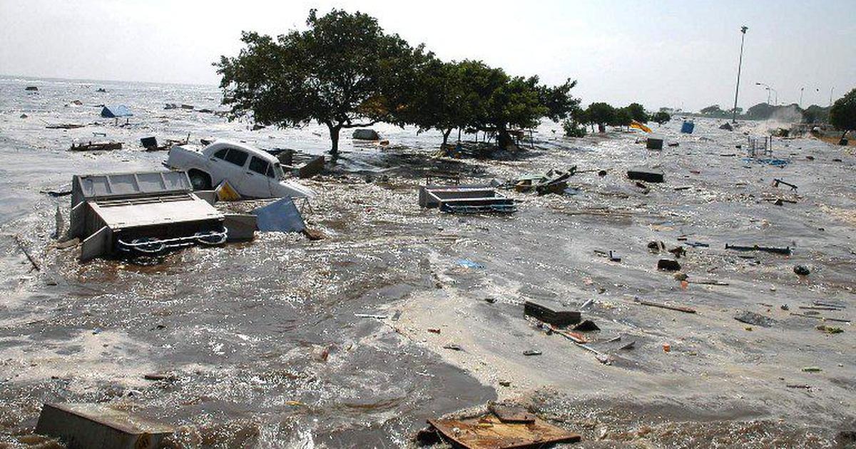
- Wave heights and reach: Run-up heights reached 20–30 m in parts of Aceh; waves inundated up to 3 km inland in some regions; arrival ranged from minutes (Andaman–Nicobar) to hours (Sri Lanka, India, Maldives, East Africa).
Human Impact
- Overall fatalities: At least 225,000–230,000 killed, making it the deadliest tsunami in history and the deadliest natural disaster of the 21st century to date.
- India-specific impact: Official Indian estimates record 10,749 deaths and 5,640 missing, with major losses in Tamil Nadu, Andhra Pradesh, and the Andaman & Nicobar Islands; local run-up heights included 10–12 m at Malacca (Car Nicobar) and Hut Bay (Little Andaman), 8 m at Campbell Bay (Great Nicobar), and ~3 m at Port Blair.
- Regional distribution: Indonesia (especially Aceh) suffered more than 130,000–200,000 deaths; Sri Lanka, Thailand, and the Maldives also experienced catastrophic loss of life and infrastructure.
India’s Affected Areas
- Mainland east coast: Tamil Nadu (worst hit), Andhra Pradesh, Kerala’s west coast also reported impacts from wrap-around waves; fisheries, coastal villages, and tourist areas were devastated.
- Andaman & Nicobar Islands: Multiple wave strikes within minutes; maximum local heights 10–12 m at Malacca and Hut Bay; Katchal Island saw the heaviest proportional losses (4,657 dead/missing of 5,312 residents).
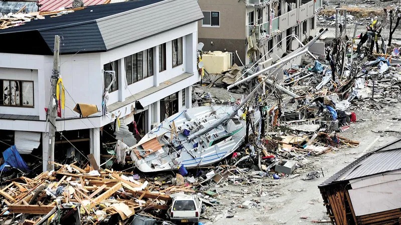
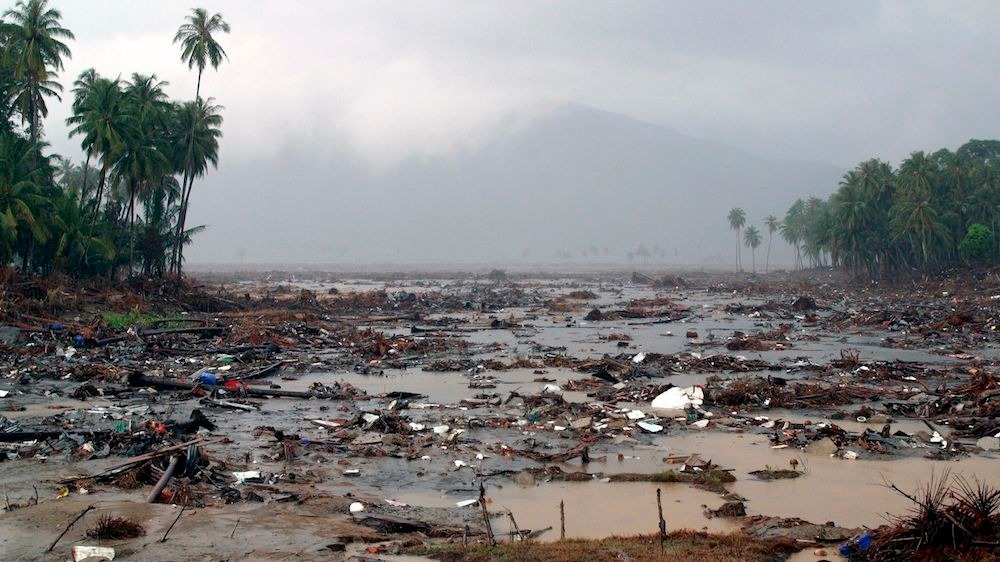
- Infrastructure and livelihoods: Destruction of homes, boats, jetties, and salinisation of fields caused long-term displacement and livelihood loss in fishing and agriculture.
Response and Relief
- National operations: India launched multi-pronged humanitarian operations by the armed forces and agencies:
- Operation Sea Waves (Andaman & Nicobar) and Operation Madad (Tamil Nadu/Andhra Pradesh) led by Navy/Armed Forces; India also extended aid abroad via Operation Castor (Maldives), Operation Rainbow (Sri Lanka), and Operation Gambhir (Indonesia) with 32 ships, 7 aircraft, and 20 helicopters deployed in rapid succession.
- International aid: Massive global relief effort mobilised; challenges included access to remote islands and conflict-affected areas, scarcity of potable water, and public health risks in the aftermath.
Why It Was So Devastating
- Lack of regional warning system: The Indian Ocean lacked a tsunami early-warning system in 2004, delaying alerts to distant shores; public awareness of tsunami signs was minimal, leading to high exposure.
- Geography and vulnerability: Low-lying coasts, dense coastal settlements, and timing during holiday seasons (e.g., Thailand) increased casualties; multiple wave trains compounded damage.
- Cascading impacts: Immediate mortality was followed by extensive displacement, disease risks, and long-term environmental damage from debris and saltwater intrusion.
Lessons and Reforms
- Indian Ocean Tsunami Warning and Mitigation System: Established post-2004 with regional nodes (including India’s INCOIS), integrating seismic, sea-level, and communication networks for rapid alerts.
- Preparedness and building codes: Greater emphasis on coastal zoning, resilient infrastructure, evacuation planning, and community education emerged across the region.
Key Dates and Facts
- 26 December 2004: Mw9.1–9.3 Sumatra–Andaman earthquake at ~07:58–07:59 (local); tsunami radiates across the Indian Ocean.
- Run-up heights: Up to 20–30 m in Aceh; India’s Andaman–Nicobar saw 8–12 m at some sites; mainland India experienced severe wave action along Tamil Nadu and Andhra Pradesh coasts.
- India casualties: 10,749 dead; 5,640 missing (official).
- HADR deployments: Indian Navy/IAF/Army launched Operation Sea Waves (A&N), Madad (TN/AP), Rainbow (Sri Lanka), Castor (Maldives), Gambhir (Indonesia) with 32 ships, 7 aircraft, 20 helicopters.
Interesting Notes
- Speed and travel time: Tsunami fronts raced across the ocean at jetliner speeds (~500–800 km/h) but slowed and rose dramatically near shore; the Maldives, Sri Lanka, and India were hit within 2–3 hours of the quake, while East Africa was struck 7+ hours later.
- Tourists among casualties: Thousands of foreign tourists in Thailand, Sri Lanka, and the Maldives were killed or missing, reflecting the disaster’s global reach.
- Scientific legacy: The event spurred advances in subduction-zone science, real-time monitoring, and public education; “Boxing Day Tsunami” remains a touchstone in global disaster-risk management.
The 2004 Indian Ocean tsunami transformed disaster preparedness worldwide: a singular geophysical rupture cascaded into a transoceanic humanitarian catastrophe, prompting enduring reforms in early warning, coastal resilience, and international HADR cooperation.


इस बारे में प्रतिक्रिया दें